
India Flood Preparedness 2026, With the IMD forecasting above-normal monsoon rainfall for India in 2026, and with climate change making extreme rainfall events both more frequent and more intense, flood preparedness is not an abstract government exercise — it is a matter of life and death for millions of Indians. Every monsoon season, floods kill hundreds of people, displace millions, destroy crops worth thousands of crores, and damage infrastructure that takes years to repair. Yet India’s flood management remains reactive rather than preventive — responding to floods after they strike rather than preventing the worst impacts before they arrive.
This comprehensive guide covers India’s flood preparedness in 2026 — which areas are most at risk, how NDRF (National Disaster Response Force) is deployed, the early warning systems that can save lives, what state governments are doing to build flood resilience, and practical steps every Indian in a flood-prone area can take to protect themselves and their families.
India’s Flood Profile: Scale and Geography
India is one of the world’s most flood-prone countries. Key facts about India’s flooding:
- Annual flood-affected area: 40-50 million hectares on average
- Annual flood deaths: 1,500-2,000 people in most years; far higher in extreme years
- Economic loss: Rs 4,000-5,000 crore in average years; Rs 30,000+ crore in severe years
- People affected annually: 30-50 million directly affected (loss of crops, property, displacement)
- Most flood-prone regions: Ganga-Brahmaputra plains (Bihar, UP, Assam, Bengal), coastal Odisha and Andhra Pradesh, Maharashtra’s Vidarbha and Marathwada, Kerala’s coastal and midland districts
Why 2026 Is a High-Risk Year for Flooding
Above-Normal Monsoon Forecast
India Flood Preparedness 2026, The IMD’s long-range monsoon forecast for 2026 — above-normal rainfall at 110%+ of Long Period Average — significantly elevates flood risk across India. Above-normal rainfall does not distribute evenly — it means some areas will receive dramatically more rain than average, increasing flood risk particularly in areas with:
- Poor urban drainage infrastructure
- Encroachment on natural water bodies and floodplains
- Full or near-full reservoirs from previous monsoon seasons
- Deforested watersheds with reduced water retention capacity
Climate Change and Extreme Rainfall
Climate change is making India’s rainfall more extreme — the same annual rainfall total is increasingly delivered in fewer, more intense events. A city might receive 200mm of rain in 4-6 hours (causing flash flooding) rather than spread across 5-6 days of moderate rain. Urban drainage systems designed for historical rainfall intensities cannot handle climate-changed rainfall. This explains why cities like Bengaluru, Hyderabad, and Delhi that previously flooded rarely are now flooding frequently even in ‘average’ monsoon years.
Most Flood-Prone Areas in India 2026
Assam and Northeast: The Annual Flood Crisis
Assam experiences severe annual flooding from the Brahmaputra River system — one of the world’s largest river systems by volume. In most years, over 30 of Assam’s 35 districts are affected by flooding. The Kaziranga National Park, home to the one-horned rhinoceros, loses hundreds of animals to floods annually. Assam’s flood management challenge is fundamentally about the enormous discharge of the Brahmaputra — a river whose flows are influenced by glacial melt, monsoon rainfall, and upstream activities in China and Bhutan.
Bihar: The Kosi and Ganga Flood Zones
Bihar’s northern districts — bordering Nepal — are among India’s most vulnerable to flooding from Nepal’s rivers, particularly the Kosi (‘the sorrow of Bihar’). The combination of flat terrain, high groundwater levels, and rivers flowing at levels above surrounding land means that barrier breaches cause catastrophic inundation. Bihar’s flood management has improved with NDRF positioning and early warning, but the vulnerability remains structural.
Kerala: The 2018 Legacy and Ongoing Risk
Kerala’s 2018 floods — the worst in the state since 1924 — killed over 400 people and caused Rs 20,000 crore in damage. The floods resulted from a combination of exceptional rainfall and controlled water releases from multiple dams that were opened simultaneously when they reached capacity. Since 2018, Kerala has improved inter-dam coordination, upgraded early warning systems, and invested in community disaster management. But the state’s geography — steep Western Ghats feeding rapid coastal rivers — creates inherent vulnerability to extreme rainfall events.
India’s Early Warning Systems for Floods
CWPRS and CWC Flood Forecasting
India Flood Preparedness 2026, The Central Water Commission (CWC) operates India’s primary flood forecasting network — with 325+ hydrological observation stations, 175+ meteorological stations, and 111 river gauge stations. CWC issues daily flood forecasts for major rivers, warning states when river levels are approaching flood stage. The lead time for most CWC warnings is 24-72 hours — sufficient to evacuate populations if local administration acts promptly.
IMD’s Integrated Monsoon Monitoring
IMD’s weather forecasting infrastructure provides increasingly accurate short-range (24-72 hour) and extended range (weekly) rainfall forecasts. The colour-coded alert system — Green (no action), Yellow (be aware), Orange (be prepared), Red (take action) — helps state governments calibrate their preparedness response. In 2026, IMD’s district-level forecasting has improved significantly through expanded automatic weather station networks and AI-enhanced forecasting models.
Community-Level Early Warning
India’s most effective flood early warning ultimately happens at the community level — when a sarpanch, ASHA worker, or flood volunteer alerts villagers that water levels upstream are rising and evacuation routes should be prepared. Smartphone-based alert systems — WhatsApp groups, automated SMS alerts, and dedicated disaster management apps — are extending the reach of early warning to individual households in vulnerable areas.
NDRF: India’s Elite Flood Response Force
What NDRF Does
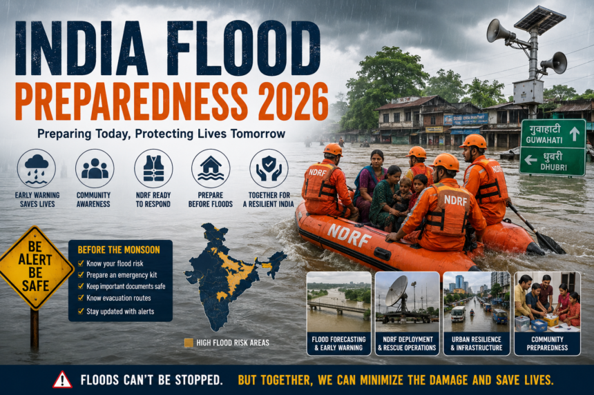
India Flood Preparedness 2026, The National Disaster Response Force is India’s primary professional disaster response capability — a paramilitary force of 15 battalions (approximately 13,000 personnel) trained specifically for disaster response including flood rescue. NDRF teams have the equipment (inflatable rescue boats, swift water rescue gear, medical facilities, communication equipment) and training to respond to disasters that overwhelm local emergency services.
NDRF Deployment in 2026 Monsoon
Ahead of the 2026 monsoon season, NDRF has pre-positioned teams in states with highest flood risk. Early deployment — positioning teams before the disaster strikes rather than dispatching them after — dramatically improves response times. States with NDRF pre-deployment include:
- Assam: Multiple teams positioned in Guwahati and district headquarters
- Bihar: Teams in Patna, Darbhanga, and Kishanganj (near Nepal border)
- UP: Teams in Varanasi, Gorakhpur, and Bahraich (high-risk districts)
- Odisha: Coastal districts ahead of potential cyclonic flooding
- Kerala: High-range districts ahead of monsoon onset
What Cities Are Doing to Become Flood-Resilient
Bengaluru’s Lake Restoration
Bengaluru’s urban flooding problem is fundamentally a problem of destroyed water bodies. The city had 272 lakes in 1960 — today it has fewer than 70. The remaining lakes’ natural capacity to absorb rainfall has been dramatically reduced by encroachment and poor maintenance. Bengaluru’s BBMP and state government are restoring lakes, desilting storm water drains, and enforcing buffer zone restrictions around lakes — slow work but essential for long-term flood mitigation.
Mumbai’s Resilience Plan
Mumbai has invested substantially in flood resilience following the 2005 floods that killed over 1,000 people. The Brihanmumbai Municipal Corporation’s (BMC) infrastructure programme includes deepened and widened storm water drains, the Brimstowad (Brihanmumbai Storm Water Drain) project, and real-time monitoring of water levels at key locations. While Mumbai still floods in extreme rain events, the response and drainage capacity has improved markedly.
Practical Flood Preparedness for Indian Households
Before the Monsoon
- Identify if your home is in a flood-prone zone — check with your municipal corporation’s flood risk map
- Prepare an emergency kit: Dry food for 3 days, water (10 litres per person), first aid kit, copies of important documents in waterproof bag
- Know your evacuation route and nearest relief camp location
- Save emergency numbers: NDRF (011-24363260), State Disaster Management Authority helpline, district administration
During Flooding
- Do not drive or walk through floodwater — even shallow fast-moving water can knock down a person
- Turn off electricity at the main switch if water enters your home
- Move to higher floors; do not wait if water is rising rapidly
- Listen to official radio and television for evacuation orders — follow them
Read More: Water Conservation in India 2026: Government Schemes, Rainwater Harvesting & Solutions
Conclusion
India Flood Preparedness 2026 — they are the result of inadequate investment in prevention, early warning, and preparedness. Every rupee spent on flood resilience infrastructure saves multiple rupees in disaster response and economic loss. At the individual level, knowing your flood risk, preparing your household, and following official guidance when floods strike can be the difference between safety and tragedy. Taza Newsz tracks India’s monsoon, disaster preparedness, and climate resilience news throughout the season.